


One version of the proposed second Bridge to Canada would be alongside the current Ambassador Bridge, which would be relegated to a backup structure.
|

The more popular version is this new construction; this view showing the Delray entry side in Detroit. Downriver was included in the original proposed sites.
|
By 2014, the two-decade question about when - and where - a second Detroit-area Bridge to Canada would be built appeared to finally be answered. The since-named Gordie Howe International Crossing planned to locate north of the Delray district on land bordering West Jefferson near the old Yellow trucking terminal.
Back then, there was a different tone from an old warrior

A sampling of the congestion which can occur on the Detroit side of the Ambassador Bridge, one of the main reasons why a second span over the Detroit River has been deemed necessary.
"You need to start now, because it's not going to be a short or cheap process. This is going to be a very difficult thing to achieve... What you're hearing now (the pros & cons being discussed) is a lot of opinions. |
Many of the headlining stories in the preceding years had dealt with Ambassador Bridge owner Manuel "Matty" Mouron's extreme opposition to an independently-run crossing competing with - and taking traffic from - his long-established bridge near downtown Detroit. Back in 2005, however, his take on the project idea was entirely different when Downriver housed four potential sites for a second span.
These proposals were green-lighted in the minds of the Detroit River International Crossing Project committee, who put together the "Partnership Border Study" site plans, and universally opposed by Downriver residents, politicians and state-level representatives as well.
|
The late Heinz Prechter first hinted his approval of such a project in the mid-1990s as a way of generating increased commerce focusing on this area. By the time a feasibility study was conducted on future east-west route upgrades Downriver some years later, not only were plans for infrastructure and funds not in place for these proposed routes, but prospects for a local International Crossing were fading along with them.
This was in spite of survey numbers showing a 40% traffic increase from ten years earlier. Furthermore, the attacks on the World Trade Center on September 11, 2001 seemed to refute the expansion idea altogether. Crossing numbers, which were expected to continue rising, were instead heading downward for an undetermined length of time. Perhaps the existing Detroit crossings were sufficient after all. And residents thought they had dodged a major hurdle.
This was in spite of survey numbers showing a 40% traffic increase from ten years earlier. Furthermore, the attacks on the World Trade Center on September 11, 2001 seemed to refute the expansion idea altogether. Crossing numbers, which were expected to continue rising, were instead heading downward for an undetermined length of time. Perhaps the existing Detroit crossings were sufficient after all. And residents thought they had dodged a major hurdle.
Detroit Bridge Partnership begins littering Downriver with its "footprints"
 Manuel Moroun in 2009.
In 2005 however, the issue came to light again, with Moroun the potential beneficiary. The choice appeared whittled down to two: A Downriver location, or a twinning of the Ambassador Bridge, which would bog down traffic all the more, especially on the Windsor side.
Now at the time, Moroun portrayed himself as one concerned about overcrowding major roadways on both sides of the border. But this could well have been simply a psychological ploy in the guise of his business interests, cementing a monopoly irregardless of what traffic levels would dictate. Area residents saw beyond any perceived personal motive though, as the opposition was as red hot as it had been before.
Intially, three sites were identified: Southfield Road in Ecorse, Pennsylvania Road in Riverview/Wyandotte, or somewhere on West Jefferson in a location to be determined. In all renderings, some neighborhoods were faced with either partial demolition or division. Mature woods were also threatened along a suggested route on Outer Drive. Bottlenecks on local roads faced more traffic clogs and woes. One plaza plan all-too-closely bordered the Sibley Quarry. And the taxpayers' questions echoed: Where would the money come from?
The first meeting would be just the start of a powerful, unified voice
 Biddle Hall hosted the first public forum on the second bridge, which attracted over 500.
At the first public meeting in 2005, held at Biddle Hall in Wyandotte, over 500 attendees were there to voice their opposition to the second span. This opposition had been stated before but had been casually brushed off by the planners. Community activist Richard Miller won raves from the crowd for declaring an overwhelming distaste for the plans: "We have (River Rouge Mayor) Gregory Joseph and Matty Moroun who want it," he said. "Why are they (the Bridge Partnership) down here, when we told you 'no'?" Very little was spoken in favor of the plan.
 King or Pennsylvania Road routes would have had a new interchange built on I-275 at Sibley, with access cutting diagonally from bottom-right of this photo.
Prior to the second meeting of 2005, to be held at Southgate's Crystal Gardens, a fourth potential site was identified as King Road, with the customs plaza overshadowing (or taking over) the McLouth / DSC Steel property. Additionally in June, the Michigan Legislature was trying to push a bill through which would make this crossing fall under public ownership, with unlimited public oversight. Whether this was a Band-Aid to soothe residents' feelings and give the proposal a kick forward was never officially mentioned.
Those voices - a total of 1,200 strong - made their volume impossible to ignore
 The JOBS Tunnel is adjacent to the abandoned Michigan Central Railway station in Detroit, and was suggested as an alternate route.
What was admittable was the increased furor witnessed at Crystal Gardens with over 1,200 in attendance, including Wayne County Executive Robert Ficano. Another activist in the audience, Tom Burkhart, announced the start of a petition drive titled "Stop The Southern Corridor." Detractors of the plan were strongly suggesting the site move to Delray or points north.
Under their reasoning the JOBS Tunnel, an abandoned international railway spur with one track, could be twin-tubed for two-way truck traffic and could ease congestion on the border... if the crossing numbers began to meet earlier, pre-9/11 estimates. The Partnership dismissed this as short-sighted thinking, stating the JOBS Tunnel expansion would not increase total capacity in an expedient manner.
Again, they were overruled in force with a passion Downriver residents are known to collectively show under tough circumstances. And County Executive Ficano shared in the message. Taking the podium, he declared "All of us are in concert in opposition."
Steel-eyed resolves often do melt in the face of mounting pressure
The plans were drawn up by the Bridge Partnership online; the site with many of the proposed drawings and layouts still exists. A later fifth proposal would have utilized Coolidge Highway in River Rouge. Incidentally, River Rouge Mayor Greg Joseph modified his initial stance as time went on, saying he though Zug Island would be an ideal bridge location, but didn't want a bridge approach built on his shores. Downriver residents had been voicing similar overtures about their shores since discussions and debate began in April.
A false alarm becomes a true relief for Downriver residents
This issue would not wallow for long. In a later meeting held on Grosse Ile, Michigan Department of Transportation Director Gloria Jeff would voice her official displeasure on the project, which would end up catching the ear of Michigan Governor Jennifer Granholm. By October 2005, the Governor officially took all Downriver sites off the table of possibility, voicing favor for a bridge closer to downtown which could still bypass the overused arteries in Detroit and Windsor.
It would be at this juncture that Manuel Moroun would change his tune, focusing only on twinning his Ambassador Bridge at all costs - legal or not - as any other project from that point forward was competition for his dollars and business, things he was too proud to give up. What followed was the well-documented, overplayed routine of Moroun's lawsuit threats every time the new Delray-based project was mentioned, ultimately delaying it for several more years.
The Downriver populace likely considered Moroun's posturing a relief of sorts, as the project's problems were no longer on their plates. The residents had spoken, and the real people in charge listened. It may be one of Downriver's finest, united hours.
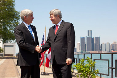
Michigan Governor Rick Snyder (left) and Canadian Prime Minister Stephen Harper meet during the official decision of the location of the new International Crossing, June 2012. (courtesy mlive.com)
|
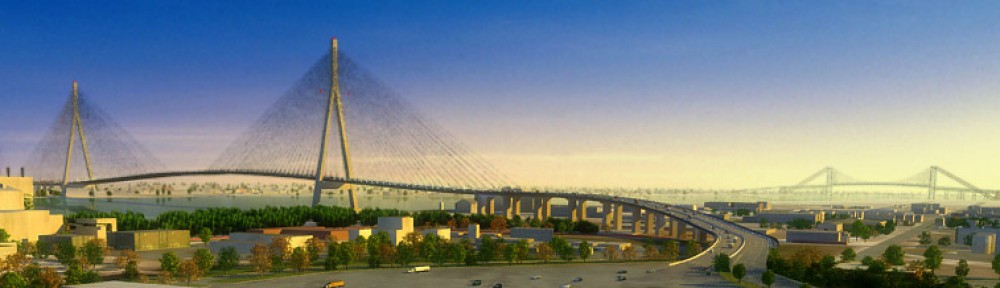
An updated bridge design photo, c.2015
"It is my sincere hope that this bridge, which bears his name, will continue this proud legacy by accelerating the flow of people, merchandise and services between our great nations for years to come." |
The five proposed Downriver routes:
KING ROAD ACCESS had two similar plans. From I-275 an access road would be built from a new Sibley Road interchange and meet up with King Road near Vining, heading eastward from there. It would have divided a subdivision near Inkster Road, and ended up too close to the boundaries of Sibley Quarry. One of the plans avoided getting too close to it, but would have taken over the old McLouth property completely. This possibility was announced later than the others.
PENNSYLVANIA ROAD ACCESS was probably the most cited possibility. Although site renderings for this location are missing, it would likely have involved a new I-275 interchange at Pennsylvania, following it in a straight line toward the river. The plaza would likely have been at the old St. Mary's Peerless Cement Property adjacent to current-day Wyandotte Shores. A potential roadblock was the location of Elf-Atochem's Riverview facility, although that plant has been demolished and cleared since.
SOUTHFIELD ROAD ACCESS would upgrade the road from I-94 eastbound. Though it had the ideal infrastructure already in place and would affect the fewest neighborhoods, the bridge plaza or an access road would have eliminated Dingell Park at the Ecorse waterfront and could well have endangered the Mud Island habitat.
OUTER DRIVE ACCESS would have utilized the same plaza location at Dingell Park, but would be accessed through I-75. A larger wooded area would have to be cut down to make room for the proposed access road, which was not designed to follow Outer Drive's curving route.
SCHAFER HIGHWAY ACCESS would have bisected the Marathon Refinery's tank farm in both renderings, perhaps a little too closely. One of the renderings would have severly impacted the neighborhood off Jefferson north of Schafer, although both would bypass River Rouge High School.

|

|
