

Downriver's formation started with Native American Indians

|
|
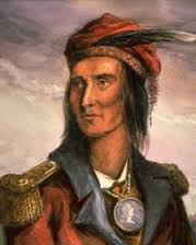
In the days before the voyages and discoveries of Samuel de Champlain and Father Louis Hennepin, the Downriver area was populated by two major Indian tribes: the Wyandot (pictured above left) and the Huron (pictured above right).
The tribe which would become the Wyandot, from which the city of Wyandotte takes its name, had its origination within the Huron Indian tribe. With between 30,000 and 45,000 tribe members, they were likely centered around present-day Montreal, Quebec before being discovered by French Fur traders in October, 1535. They would immigrate along with the fur traders to the Michigan territory. However, their number would dwindle significantly to one-fourth of its original size due to wars and epidemics in the 1600s.
The Huron tribe, meanwhile, was considerably larger, having formed along the Canadian border of Lake Ontario, then having moved to Georgian Bay, being discovered in 1615 by de Champlain. These natives were known as the Wendat which, translated, means "peninsula dwellers."
The Wyandot Indians local history has come to know so well developed with a merger of the Huron and Petun tribes in the early 1700s, a variation of the Wendat. The western branch of this tribe would be the ones to redevelop themselves in Ohio and southern Michigan, including the Downriver area.
Ecorse Territory was among the first settlements in the years following Ft. Detroit

Antoine de la Mothe Cadillac, the father of Detroit and likely the original founding non-native settler of Downriver, approx. 1701.
|

|

Ribbon Farms make their debut around present-day Historic Fort Wayne in Detroit.
|
Antoine de la Mothe Cadillac established modern-day Detroit in 1701 at Fort Pontchatrain; the area now known as Ecorse would also be governed by Cadillac by a settlement of French habitants. This may well have been the very first organized settlement in the present-day Downriver area, even pre-dating Pierre Michael Campeau's purported arrival into the area, the occurence of which can vary from the 1750s until as late as 1795.
Chief Pontiac calls an Indian Council in 1763 in an effort to keep their presence strong
 Chief Pontiac was determined not to integrate the Great Lakes. Chief Pontiac was determined not to integrate the Great Lakes.
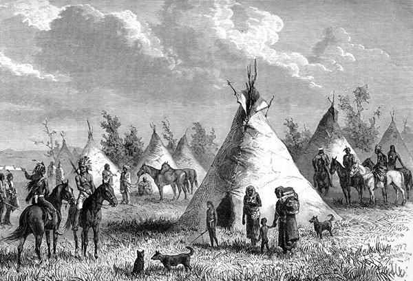
Possibly the most important and far-reaching Indian council ever assembled was held in what is now Lincoln Park in 1763, when the great Ottawa Chieftain Pontiac called the Indians of the Midwest together to plot the destruction of the encroaching white man.
History does not tell the exact location of the great assembly, which drew warriors and chiefs from every tribe and nation of Indians in the Great Lakes Region. We know only that it was held on the banks of the Ecorse River. Tradition relates, however, that the Indians met near the confluence of the north and south branches of the Ecorse River, near the neck of land which still bears the name "Council Point" or Pontiac Point. The tepees of the huge band of warriors were probably erected throughout what is now Lincoln Park. |
Therefore, my brothers, we must all swear their destruction and wait no longer. Nothing prevents us; they are few in numbers, and we can accomplish it. 
The conference being held in Lincoln Park, c.1763
|
This would begin a three to four year period of unrest in the Great Lakes Region as this battle, called Pontiac's War, would rage from 1763 to 1766. The ultimate goal was to utilize a group of 300 to capture Fort Detroit and head off the immigration of the white man. This initial siege did not turn in Chief Pontiac's favor, although it would succeed in broadening the scope of the war's coverage area; most of the Great Lakes and Midwest areas.
Pontiac would withdraw to the Illinois country by October of 1763. He would have some success in the conflict, having captured some areas near the Alleghenies. Toward the end of the war, Pontiac appeared to be mellowing from his earlier aggressive stances against white settlement, choosing instead to become a spokesperson. The hostilities officially ended in a meeting on July 25, 1766, in Oswego, New York.
Chief Pontiac was attacked and murdered on April 20, 1769 by a member of the Peoria People Indian tribe in an act of revenge. Settlements Downriver continued to increase as the years passed.
So, did Pierre Michael Campeau really play a role in our settlements?
|
The Arrival of Pierre St. Cosme |
|
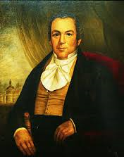
Various sources have mentioned that Pierre Michael Campeau was in fact the first white man to settle into the area. However, even the earliest time of his arrival is pegged at 1750, nearly 50 years after Cadillac's establishment at Fort Pontchatrain. Campeau's arrival date varies wildly from that point until as late as 1795; by that time, pioneering families were already purchasing land parcels and settling into the present-day Ecorse and Lincoln Park areas. Internet resources gained for this article listed very little about Campeau, with no photos available. It is possible he could be more of a minor settler, though the multiple sources cited above cannot necessarily be disputed without solid proof.
|

Only thirteen years after Pontiac's ill-fated war council, leading chiefs of the Potowatomi Nation deeded a huge tract of land to a Frenchman living at Detroit: Pierre St. Cosme. The grant, dated July 1, 1776, was signed four days before the Declaration of Independence was adopted, and would give St. Cosme and his two sons a piece of property which included most of present-day Allen Park, Ecorse, Lincoln Park, and a portion of Wyandotte.
This property extended approximately four miles back from the river. Its northern boundary followed what is now Southfield Road, while its southern flank followed a line close to present-day Goddard Road. The cost of the transaction must not have been too expensive; it has been described that St. Cosme, "for love and affection," had been given a tract of land which today is worth untold millions of dollars. St. Cosme lived in the area until his death in 1787; his name would continue to live on with the naming of State Street as St. Cosme Line (the present-day Southfield Road in Lincoln Park) for many years. |
Grosse Ile is established, just days after American Independence
 Signatures on the Grosse Ile Treaty of 1776.
As far back as 1718, a memoir belonging to the establishing Indian tribes on the Grosse Ile territory (the Fox, Sacs, Kikapoos and Potawatomies among them) stated there were long-lingering doubts whether Cadillac's Fort Detroit should instead have been founded on the island which they named Kitcheminishen. The apparent reason for this idea's hesitation was their apprehension that "the timber would some day fail."
Two days after signing the Declaration of Independence (July 6, 1776), the territory of present-day Grosse Ile Township was sold to brothers Alexander and William Macomb, by a grouping of various Indian tribes, which included the Fox, the Sacs, the Kikapoos and the Potawatomies. Secretary of State (and future President) James Monroe was among the signers. Historians assume that the Macomb brothers believed that, by purchasing this deed through the transfer of items of value, they had in fact obtained full ownership rights. In any case, the Macomb brothers are considered to be the founders, and first legal owners, of Grosse Ile; this is because the Potawatomis, and later the United States Government, respected the Macombs' perceived rights to take possession of the island.
Two days after signing the Declaration of Independence (July 6, 1776), the territory of present-day Grosse Ile Township was sold to brothers Alexander and William Macomb, by a grouping of various Indian tribes, which included the Fox, the Sacs, the Kikapoos and the Potawatomies. Secretary of State (and future President) James Monroe was among the signers. Historians assume that the Macomb brothers believed that, by purchasing this deed through the transfer of items of value, they had in fact obtained full ownership rights. In any case, the Macomb brothers are considered to be the founders, and first legal owners, of Grosse Ile; this is because the Potawatomis, and later the United States Government, respected the Macombs' perceived rights to take possession of the island.
Slave trade active - but more respectful - around our area
James Duperon Baby, undated. He purchased an 1800s era slave from a local landowner based in Springwells Township, just north of the Rouge River.
|
Meanwhile, various Indian tribes would be at individual wars with invading settlers over already established plantations. Early slave activity was most prevalent among some of these tribes, who spun off these slaves to New York, the Indiana territory, and other areas. It was from these territories that some of the future state of Michigan's most notable settlers would end up employing the slaves on their lands.
In a stark contrast to the dismal working atmospheres of the southern reaches of the country, the slaves in the northern territories were reported to have been treated with a great amount of respect during and after their service, although slavery as a whole was not condoned by the greater government. Many would receive the sacrament of Baptism, many others received donation lots in exchange for their service, and several could also speak the French language fluently. There was no "doctrine of higher law" applied to the slaves of the northern territories as were there to their southern counterparts. |
Major Joseph Campau would be one of the major Detroit-area figures to have bought into the trade. Another would be James Duperon Baby, who owned land at the southern tip of the future Springwells Township (today's Delray). For example, on October 22nd, 1793, a twelve-year-old named Frank would be sold to Baby for the sum, in 1872 dollars, of $532.50. The seller in this case was Phillip Jonciere, who laid claim to plantations on both sides of the Rouge River, including the future River Rouge territory Downriver.
Northern slavery would begin to vanish, in large part thanks to an Act signed by the United States Congress in July of 1787 making slavery or other servitude unlawful unless used as punishment for crimes. However, the general idea began to fade before that time, as many enslaved members were liberated by their owners, or sold to owners outside of the Great Lakes and Ohio Valley area. The Act of 1787 was put in place primarily to prevent the spread of slavery north and west of the Ohio Valley.
Northern slavery would begin to vanish, in large part thanks to an Act signed by the United States Congress in July of 1787 making slavery or other servitude unlawful unless used as punishment for crimes. However, the general idea began to fade before that time, as many enslaved members were liberated by their owners, or sold to owners outside of the Great Lakes and Ohio Valley area. The Act of 1787 was put in place primarily to prevent the spread of slavery north and west of the Ohio Valley.
Pontiac's War, Part Two? Or just a hiccup?
|
Although Grosse Ile's "purchase" seemed to go as smoothly as possible, turnover of the eventual United States territories were noticeably more difficult. Even over a decade after the end of the American Revolutionary War, Great Britain was still in technical control of the areas deeded to the United States, as its government was still trying to gain its footing.
In addition, the native Indians were once again moving toward another anti-white settler movement, despite the fact Pontiac's War did not gain them traction initially. |
The British and Indian unite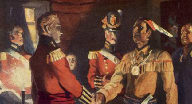
'Meeting of Isaac Brock and Tecumseh, 1812 (painting by C.W. Jeffreys, "courtesy')
|
In this instance, the Indian Tribes were also joined by theBritish in their quest to eliminate American encroachment, and this would begin a partnership that would last until the War of 1812.
When control of Michigan and the surrounding areas was finally in the hands of the new American Government by 1796, there existed many conflicting land claims along the Detroit and Rouge Rivers. The U.S. Congress, therefore, in 1806 created a Board of Land Commissioners to adjust these claims. Aaron Greeley, an experienced surveyor, was appointed in 1808 to map this area.
When control of Michigan and the surrounding areas was finally in the hands of the new American Government by 1796, there existed many conflicting land claims along the Detroit and Rouge Rivers. The U.S. Congress, therefore, in 1806 created a Board of Land Commissioners to adjust these claims. Aaron Greeley, an experienced surveyor, was appointed in 1808 to map this area.
As lands developed, roads and pathways made themselves known
"The road is the physical sign or symbol by which you will best understand any age or people. If they have no roads, they are savages, for the road is the creation of man and a type of civilization."
The first effort at road building was sort of a bridle path which ran along the west bank of the Detroit River and through the swamps in the vicinity of Toledo to Cleveland. This followed an Indian trail through the Black Swamp to Detroit and was known as the French-Indian Trail. This swamp consisted of a slightly elevated basin of impervious clay upon which rested a thick stratum of fertile black loam, and the surface was so level that water could not escape except by evaporation. As there wasn't much evaporation, this area was always wet and travelers virtually had to swim through the swamp. Despite these obstacles, roads came into existence and an early bridle path became a modern thoroughfare which today is known as the River Road.
On November 25, 1808, by the Treaty of Brownstown, the Indians granted to the United States a tract of land two miles wide, which extended westward and northward from the Connecticut Western Reserve to the foot of the Rapids of the Miamis of the Lakes, with the understanding that a road should by built along this tract. Three years later the President authorized a party to survey and mark this road and six thousand dollars was set aside to cover the expense necessary to construct a road across the "Black Swamp."
A second effort at highway construction was a little more successful. In 1817, from one hundred and fifty to two hundred troops, then stationed at Detroit, were employed in opening a road to Fort Meigs on the Miami (Maumee) via Frenchtown (Monroe). This road was established by authority as a military road 66 feet wide and was laid out and created by order of the President. A resolution was passed by Congress, April 4, 1818, requesting the Secretary of War to communicate progress and prospects for the completion of this road.
Other Indian communities helped |
What happened to the Wyandot? |
|
The Wyandot Indians were joining with other tribes to work toward peaceful overtures in Cadillac's former settlement. By 1807 they played, along with the Odawa, Ojibwein and Potawatomi in signing the Treaty Of Detroit. The agreement, between the tribes and Michigan Territorial representative William Hull, ended up giving the United States a part of today's southeastern portion of the Michigan territory
Within this scope of events, settlements continued their establishments in the Ecorse / Lincoln Park / River Rouge area, close to Cadillac's Fort Detroit. Family names entering including the Campaus, Salliottes, Labadies, LeBlancs, Goodells, Bondies, Drouillards and many others. The early settlers continued to purchase the strip farms, which were only a few hundred yards wide on the riverfront but extended back into the forest for several miles. The St. Cosme Land Grant farms fronted on the Detroit River, while other farms fronted on the Rouge River and ended on the northern edge of the St. Cosme property, which became known as the St. Cosme Line. As the years went by and the families grew, new generations built homes farther back from the rivers; and early in the 1800's, the first homes were probably built in what was to become Lincoln Park. The first settlement was not made near the present center of the city, however, but along the southern edge near Goddard Road. An old map of the area, made about 1818 by Bela Hubbard, shows homes only in this section, which, as recently as the 1950s, was one of the city's few remaining vacant areas. Among the early settlers in the Lincoln Park area were the Monties, who settled on the street which now bears the family name; the Bondies and Laffertys along the west banks of the Ecorse Creek (now River Drive) and the Drouillards in the south section near Goddard Road. |
In 1818, there were a series of treaties, six in all, signed between the United States and Indian reservations. A treaty with the Wyandot was the first to be ratified. Territorial Governor Lewis Cass exchanged their Downriver land (near present-day Brownstown & Flat Rock) for land in Huron Township. Then in the 1840s, most of the surviving Wyandot people were displaced to Kansas through the US federal policy of forced Indian removal.
Using the funds they received for their lands in Ohio, the Wyandot purchased 23,000 acres of land for $46,080 in what is now Wyandotte County, Kansas from the Delaware. It was a more-or-less square parcel north and west of the junction of the Kansas and Missouri Rivers. An October 1855 article in the New York Times reported that the Wyandot were free (they had been accepted as US citizens) and without the restrictions placed on other tribes. Their leaders were unanimously pro-slavery; meaning 900-1,000 additional votes in opposition to the Free State movement of Kansas. Today it is estimated more than 4,000 Wyandot can be found in eastern Kansas and Oklahoma. |
Monguagon Township territory plays an important role during the War of 1812
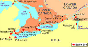 Major battle sites during the War of 1812.
Known officially in the history books as the Battle of Maguaga, and alternately known as Battle of the Oakwoods, the Battle of the Monguagon was a skirmish between American and British forces which began with a blockaded path for needed supplies.
American Brigadier-General William Hull had settled to the Fort Ponchatrain area, looking to strategize its location in an effort to launch a full-fledged ground assault on Upper Canada. Second thoughts of apprehension caused this attack not to go through, and Hull left the area for a time to tend to a developing British takeover of Mackinac Island.
American Brigadier-General William Hull had settled to the Fort Ponchatrain area, looking to strategize its location in an effort to launch a full-fledged ground assault on Upper Canada. Second thoughts of apprehension caused this attack not to go through, and Hull left the area for a time to tend to a developing British takeover of Mackinac Island.
Indian Chief Tecumseh helped turn back William Hull's original troop attempting to receive needed rations.
|

Brigadier-General William Hull.
|
Lt-Col. James Miller, who commandeered the second troop sent by Hull to retrieve the rations.
|
Hull's garrison of fighters were desperately in need of rations, and a volunteer group led by Captain Henry Brush arranged to meet with Hull's brigade at Miami Rapids. Included were 300 heads of cattle and 1,400 pounds of flour. This transaction ran into an initial blockade (the Battle of Brownstown) by British Captain Adam Muir of the 41st Regiment, as well as the Indian Chief Tecumseh, whose forces drove Hull's detachment back.
Undeterred, and with his brigade likely getting desperate, Hull sent Lieutenant-Colonial James Miller to command a second attempt to Miami Rapids to obtain the supplies. This brigade was much larger, numbering 580 (regular fighters as well as Ohio Volunteers). However, they would run into another blockade by Muir and a group of 205 British, Canadian and Native American men standing on land which today is the city of Trenton. Miller's men began to advance, wearing out the British front.
The accuracy of the British fighters was definitely called into question when they fired on supposed enemy targets moving behind them. These, however, were members of the Potawatomi tribe who were loyal to the British. Not clearly seeing who was firing at them, the Potawatomi assumed the fire came from American troops and began their own assault. It took time for the common sides to realize they were fighting each other due to those assumptions.
The American advance, meanwhile, appeared to be fading. As a result, Muir commissioned the bugler of the 41st Regiment to lead a charge. Due to another unfortunate misinterpretation, this charge fizzled as well. Another battery of the 41st Regiment assumed the bugle call was a "retreat" order, where the opposite was the intent. As they retreated, Miller advanced past Muir's original position and then saw his fighters from a distance. However, Miller did not elect to go further; this progress having satisfied him.
The battle numbers on their own were not satisfying for the American side, though: totals were 18 killed and 64 wounded. There were six deaths, 22 wounded, and two missing from the combined opposition. Miller's state of mind was shaken by the losses. In addition, his fighters had discarded their knapsacks behind them to keep up an effective fight; it would require a trip from whence they came to retrieve these necessities.
This trip, Miller was rue to take. He instead elected to camp nearby and stayed there two days despite repeated orders by Hull to continue to Miami Heights. Muir's brigade, unbeknown to Miller, had already left the area. Disgusted, Hull ordered Miller back to the Detroit territory, where he would certainly have faced court-martial had the opportunity arose.
Further battles in the War of 1812 were fought in areas east (see map above). Although Maguaga is not shown in it as being a "major" battle, it is considered the first in the War to earn the title of "battle."
The Flat Rock territory begins to develop and anchor Downriver's southern border
The first mention of any settlers in the area later to become Flat Rock was made by a French priest, Fr. Jean Dilhet. In describing his parish in 1798 he had included "Grosse Roche," referring to a settlement named after the outcropping of limestone rock on the south side of the Huron River.
The first European-American settlers in Flat Rock territory were Michael Vreeland and his five grown sons, between 1811 and 1820. Michael had been captured by British Rangers during the American Revolutionary War and released after American Independence. The family ended up purchasing 800 acres in the territory. The town was called the Village of Vreeland until some time after the current townships were platted (1838), when the Vreeland family would sell off the majority of the land and relinquish control of the area.
The Vreeland family built the area's first grain & lumber mill, having brought the grinding stones from New York. Descendants of Michael Vreeland still live in the town and have attended Flat Rock Public Schools, being the seventh generation (to date) to reside in the town their family founded.
By 1828, the village of Flat Rock had four stores, two sawmills, a wood carding mill, a flour mill and 250 inhabitants, serving as a center mainly for farmers who lived in the area immediately surrounding the settlement. The village would eventually be platted and recorded in 1838 by the Gibraltar & Flat Rock Land Company. They were attempting to build a canal to connect Lake Erie and Lake Michigan; an effort which ultimately failed not long afterward.
The State Legislature acts in 1827 as Ecorse Township is platted and formed
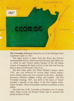
Ecorse Township as in originally appeared upon the declaration by Lewis Cass in 1827, which created it as well as four others, including Brownstown.
|
Five years after an error-filled battle, January 15, 1818, recognized a strong proclamation. It was given by Lewis Cass, governor of the Michigan Territories, and would establish initial township territories surrounding Detroit in Wayne County: Hamtramck, Huron, St. Clair, Springwells, and Monguagon. These new territories were granted courtesy of a Court of General Sessions back on November 6, 1790, which decreed any such designation would be governed by a commissioner.
Eight years later, on April 12, 1827, Governor Cass eliminated the commissioner position for these territories, and also developed new townships, including Brownstown, Bucklin, Detroit, Ecorse and Plymouth. It may be noted here that, prior to organizing as its own township many years later, Grosse Ile was part of Monguagon Township. As described in the Wayne County Census report of 1884: |
Ecorse Township was organized by Legislative Council, 12 April 1827 embracing T3S-R10E and fractional T3S-R11E together with all the tract of county between River Rouge and the townships mentioned, and east of the farm of Conrad Ten Eyck and the Detroit River
(Territory Laws Volume 2:479)
(Territory Laws Volume 2:479)

|

|
