

ECORSE ROAD

In the days before the I-94 / Telegraph interchange was completely overhauled to its present-day look, gallantry signs looking northbound on Telegraph approaching Ecorse Road appeared to have a blank spot on their left side, hiding a highway badge. This would have been Ecorse Road's original route marker.
In its earliest days, Ecorse Road was not tied into this designation, however. The original route more or less followed Michigan Avenue's present day route once the number originated north of Battle Creek. US-17 would feed into downtown Detroit in much the same way US-12 currently does. Six years after route numbers were first assigned to certain roads (in 1926), Ecorse Road would receive the M-17 designation in its entirety from Ypsilanti to Lincoln Park.
Unlike Ecorse Road itself, which ended at Allen Road / Roosevelt Road as it does today in Allen Park, the original M-17 routing took it past that mark, eventually going onto Southfield Road to Dix-Toledo Hwy (US-25), which would then follow north to connect with its original entry into downtown Detroit, closer to Michigan Avenue. This was completed by 1937.
With various completion of I-94 stretches over the next couple decades, M-17's Downriver boundaries would be cut; first in 1968, when the stretch following Southfield and Dix-Toledo Highways, heading toward downtown Detroit would be eliminated, and the M-17 standing would end in downtown Allen Park at Southfield Road.
The following year (1969) would eliminate all references to M-17 Downriver, as its eastern end would match its eastern end today: on US-12 (Michigan Ave. ) southeast of downtown Ypsilanti.
TELEGRAPH ROAD

Telegraph Road was initially formed as a simple access road around 1835, named for telegraph lines than ran the distance north and south not long after the technology was put into use thanks to communications pioneer John James Speed, who put together these lines initially around 1848, connecting Detroit with points in Ohio. The consensus here is that Speed's route obtained the Telegraph Road name, as there were only two lines running south from Detroit during this time period.

It was simply a minor dirt road at first: as early as 1842, in fact, residents in the new areas were petitioning to make this route "more passable." Prior to this, Pardee Road was considered the main north/south road connecting neighboring Dearborn to the north with Flat Rock, which it would likely remain into the later 1850s, as Taylor Township claimed Telegraph was not a through road. When intially completed, Telegraph only extended to Michigan Avenue near Dearbornville to serve families and farms adjacent.
The new century would bring vast improvements as, beginning in the 1910s, crews from Dearborn began sorely needed upgrades and widening to the route. By 1919, Wayne County would chime in and begin widening processes in the Downriver area. It would take until the 1930s for Telegraph to finally meet its modern northern terminus in Pontiac.
It did not take long after these upgrades occurred for the directors of the newly formed US Highway System to designate this as US Route 24 headed northerly from Ohio to at least the Detroit city limits. The US-24 designation has been in place Downriver since 1926.
* Details about Telegraph's widening to a divided highway are still being researched.
DIX-TOLEDO HIGHWAY
|
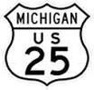
At one time, Michigan had six more major U.S. highway routes than they currently do. The original boundary lines for this highway would have extended southerly from Port Huron, thru Detroit and Toledo, ending in Brunswick, Georgia.
|
First to have opened was the original routing of US-24, which much follows today's Telegraph Road, in the mid-1920s. This ultimately bypassed the burgeoning city of Detroit. Wishing a route that would go through downtown Detroit, U.S. 25 was extended north from its former ending in Toledo, to be open in its entirety by 1930.
This new routing of US-25 made use of already-existing roads with no new substantial construction planned. Among roads receiving this designation would be Dixie Highway in Monroe County, parts of Telegraph in Monroe & Wayne County (which would then have both US-24 and 25 designations at the same time), and portions of Gratiot Avenue in Wayne, Oakland and St. Clair Counties. The main connector to these would, of course, be Dix-Toledo Highway running north from West Road up to Oakwood Blvd. This route was not completed in time, so portions of US-24 had to revert to the US-25 concurrent routing until the main route was open by 1930.
This new routing of US-25 made use of already-existing roads with no new substantial construction planned. Among roads receiving this designation would be Dixie Highway in Monroe County, parts of Telegraph in Monroe & Wayne County (which would then have both US-24 and 25 designations at the same time), and portions of Gratiot Avenue in Wayne, Oakland and St. Clair Counties. The main connector to these would, of course, be Dix-Toledo Highway running north from West Road up to Oakwood Blvd. This route was not completed in time, so portions of US-24 had to revert to the US-25 concurrent routing until the main route was open by 1930.

Widening of US-25 Dix Toledo in Lincoln Park, circa 1958.
|
The route, expanded to four lanes as traffic increased, would barely be open 25 years before plans were in motion to replace both US-24 AND US-25 with a freeway running from Toledo toward Detroit. The Freeway was codenamed US-24A. From the late 1950s on, bits and pieces of US-25 were commissioned to the history books, becoming parts of I-94 and I-75's new routes.
Although US-24 (Telegraph) was left numbered in its entirety, US-25 was retired from Downriver service in 1968, five years before the entire route was would end up being decommissioned in 1973. |
SOUTHFIELD ROAD / EXPRESSWAY
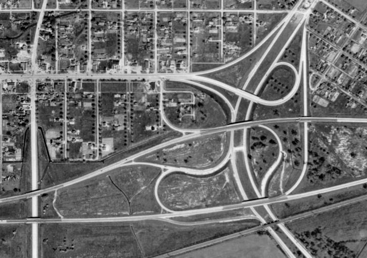
Southfield and I-94 interchange as it appeared in 1949. Before freeway status, Southfield continued as a boulevard north. (Courtesy Steve Frey)
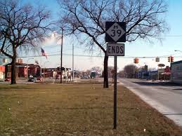
The M-39 designation ends here in Lincoln Park at Lafayettte Street due to differences with M-DOT code.
|
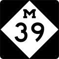
The M-39 designation has had two different locations other than the present-day Southfield Hwy/Fwy: A trunkline in mid-west Michigan, as well as a designation in the Detroit area approximately two miles east of its current alignment.
The original M-39 was actually a route from Grand Rapids to Lansing, competing with M-16 between the same two towns. By the late 1930s, this designation had been removed. The second version of M-39 began in 1939 when Schaefer Hwy, tagged then as M-3 (a number now associated with Gratiot Avenue) was redesignated. It began at the intersection of then-US 25 (Dix-Toledo) in Melvindale, headed northerly via Schaefer Hwy, with its end at Grand River Avenue in west Detroit (which, ironically, also was tagged M-16). The reason for this redesignation of Dix-Toledo and Schaefer parcels was the State Highway Department's decree to eliminate all single-digit highway designations in preparation for what would be the construction of the national highway system. Twenty years later (1959), the M-39 designation was removed from Schaefer Hwy and moved two miles west to Southfield Road between Allen Park and the city of Southfield (at the present-day Lodge Freeway). Remember that Southfield was entirely a road from point to point at that time. It was a divided highway, much the same way the present Allen Park road is, from I-94 northbound to Seven Mile Road; it was undivided the rest of the way north. The freeway alignment did not come into existence until 1966. |
It would eventually extend southward from the Lodge Freeway to the intersection of Southfield and Fort Street. It was shortened by less than a mile by 1988, when the eastern end of M-39 was moved to Lafayette Street; given the fact that median parking was still in existence east of that point, it did not meet M-DOT's specifications for a "highway."
FORT STREET

M-85 in Michigan initially began its existence on August 27, 1919 over in Montcalm County through the main city of Stanton. A further extension of this original route was provided in 1929 with the route headed northerly to the town of Edmore. The following year, this designation vanished with the extension of nearby M-57; it had lasted eleven years.
In 1931, M-85 received its second location on the other side of the Lower Peninsula, running from the cities of Caro to Mayville. This version would only last ten years when the number would be decommissioned again (officially March 14, 1941) due to the extension and improvement of the nearby M-24 route.
In 1931, M-85 received its second location on the other side of the Lower Peninsula, running from the cities of Caro to Mayville. This version would only last ten years when the number would be decommissioned again (officially March 14, 1941) due to the extension and improvement of the nearby M-24 route.
|
Fifteen years would pass before M-85 was commissioned again, this time along Fort Street between Gibraltar Road in Gibraltar, and Oakwood Boulevard in Detroit. A temporary M-85 designation was also given to various surface streets leading into Detroit from the partial Detroit-Toledo expressway, which at that time was still in the planning stages Downriver.
The northern end of the M-85 designation changed once: in 1967 the terminus was relocated from Oakwood Boulevard to Schaefer Highway. This re-assignment took place on the same day (February 9) that the US-25 designation was officially withdrawn from Dix-Toledo Highway Downriver. |

Fort Street in downtown Lincoln Park, circa 1924. It would be 32 more years before it would earn the designation of M-85.
|
INTERSTATE 75 / FISHER FREEWAY
|
Prior to Michigan's incorporation into statehood in 1837, the traffic landscape bore no resemblance to what it would look like in the early 1900s, let alone today.
Any roads not "constructed" from area pioneers' footsteps were Indian trails. The closest major one nearby connected Detroit with Monroe and Toledo (north of Detroit it would join the Saginaw Trail). |
Prior to Michigan's incorporation into statehood in 1837, the traffic landscape bore no resemblance to what it would look like in the early 1900s, let alone today.
Any roads not "constructed" from area pioneers' footsteps were Indian trails. The closest major one nearby connected Detroit with Monroe and Toledo (north of Detroit it would join the Saginaw Trail).
In the latter part of the 19th century, the Michigan State Legislature recognized a better system of roads needed to be implemented to draw people to the new state. The Legislature chartered various private firms to build and operate Plank Roads, better known as Turnpike Roads. The Plank Road designation was not a term; it was a fact: the earliest roads were constructed with oak planks, before an eventual switch to gravel roadways became the consensus of new construction.
However, while a total of 202 potential Turnpike Roads were actually approved by the Legislature at the turn of the 20th century, only twenty-three were actually constructed. Bids were won and, seemingly, ignored.
Whether or not the next step occurred due to the recognition of this fact, the Michigan State Trunkline System was inaugurated on May 13, 1913. Main roads at this time were classified as "divisions," much like a traveler will see in rural areas of Ontario (which had roads termed "division," "concession," and "line"). Our "big road" was Division 1, between Detroit and Toledo. It would take six years before this and accompanying routes would show up on maps: in 1919, Division 1 was classified as the first generation of M-10 (given to today's Lodge Freeway). In later years, when the M-10 designation was rerouted, this stretch became parts of US-24 and US-25.
The modern route of today's I-75 was first mapped in 1947 for the future Interstate Highway System, and was widely published by 1955 in a book entitled: General Location Of National System of Interstate Highways Including All Additional Routes at Urban Areas Designated In September 1955. Fortunately, the publication had a shorter name: the Yellow Book.
Prior to that publication, the Michigan Turnpike Authority (MTA) was created in 1951. The Authority's first idea was to construct a series of tolled freeways; one of which would run between Bridgeport and Downriver's Rockwood municipality. However, Charles Ziegler, then the State Highway Commissioner, had a noted distrust of private companies interfering with potential statewide road projects, as he deemed them too important to mess with. These projects by the MTA were therefore stalled.
The result was apparently a lose-lose scenario: people were getting tired of the constant delays in construction, but no one wanted to revert back to the MTA's toll freeway idea. Even semi-truckers were willing to support a gas tax increase to raise the funds rather than paying by individual use. In 1955, the City of Detroit would step in and officially deny the MTA its request to route a highway bordering Rouge Park (near current-day Outer Drive and Warren Avenue). Despite MTA's appeals, the Michigan Supreme Court upheld the city's verdict later that year.
Still working on the drafts for the route of the present-day I-75 revealed a route closely following Telegraph Road thru most of its run. In December of 1955, its proposed routing was finally extended south of Rockwood. The Federal Highway Act of 1956 gave important credence to freeway construction, undermining the MTA's efforts with a promise to build the freeway from border to border (Toledo to Sault St. Marie).
The MTA still had one more gasp to change peoples' thinking. The Turnpike Authority attempted to sell bonds to finance its projects, but received no takers from financiers, who were afraid to compete against the companies building freeways under the FHA of 1956. Out of the headlines later that year, the MTA was finally abolished by law in 1962.
It was originally proposed that the section of I-75 between Detroit and Toledo be powered by electricity, courtesy of General Motors (a nod to Henry Ford's attempt to electrify the DT&I railroad more than thirty years earlier). Some preliminary testing of this had been done at Ohio State University; the results of which were both unknown and not followed up.
Once cleared to build, the construction of I-75 was rather quick: it was built as far north as the Telegraph connector (southbound Exit 35) in 1963; by 1966 it reached Southfield Road, and was completed in full by 1969.
The freeway has had four names, of which three are still in use. During its formative years, it was referred to as the Detroit-Toledo Expressway. It is most popularly known as the Fisher Freeway, named in a ceremony (September 17, 1970) honoring the brothers who operated Fisher Body.
Though not signed as such, the entire Michigan stretch of I-75 is known as the American Legion Memorial Freeway. Additionally, it was known as the Michigan Bicentennial Freedom Way from 1976 until the name was retired in 2001.
EDSEL FORD EXPRESSWAY

|
Not only is Interstate 94 Michigan's oldest, but its general route has a history going back to the St. Joseph Indian Trail, which traces its beginning prior to Michigan's Statehood in 1837, as shown to the left. With the formation of the State Trunkline Highway System on May 13, 1913, a rough route patterning today's I-94 was designated Division 6.
|
The first stretch of freeway-grade routing was constructed immediately before and during World War II, given a numerical designation (M-112) and a name (Willow Run Expressway) starting in 1941. From Willow Run, the freeway was extended through Sumpter, Romulus, Taylor Township, Ecorse Township and Melvindale in stages from 1943, completed by March 1945. This section was named the Detroit Industrial Expressway, with the Detroit section called the Crosstown Expressway. Due to a petition being passed, this entire local segment was renamed the Edsel Ford Freeway in April 1946, the name it currently holds for most of its Downriver and Detroit route.
Original planning for the development of the modern Interstate Highway System in the late 1940s had this route actually pegged as I-92 from Downriver westward toward Benton Harbor. By July of 1958, to accomodate the route having the same number throughout its distance, it was officially made into I-94.
This stretch of freeway was intended to feature a high-speed rail line running the length of the median from Willow Run to the Detroit city limits in the mid-1950s, but a system was never developed.
The original portion of the freeway near Willow Run was first reconstructed and widened in 1972. The portion through Taylor originally had back-to-back left-hand exit and left-hand entrance ramps at Telegraph and Ecorse Roads, causing many bottlenecks and chances for accident. To improve traffic conditions (and in time with the upcoming Super Bowl in Detroit), a new Telegraph Road interchange was constructed in 2003-04.
INTERSTATE 275

|
In the summer of 1968, the Federal-Aid Highway Act was passed, which called for an additional 1,500 national highway miles, perhaps to avert congestion in metropolitan areas. The Michigan State Highway Commission put in a request for an additional 600 interstate miles of its own, part of which would extend a proposed I-275 Detroit bypass up to the Clarkston area from its initial ending at the present day I-96 / I-696 interchange.
|
The request was denied as, not only would it have taken a sizeable chunk of the federal allotment, there was in fact no I-275 except in the planning stages, so no verifiable "hardship" had yet been identified. To date and in spite of further attempts, I-275's original route may never be realized.
On July 14, 1972, the basic route of I-275 through Downriver (and up to Five Mile Road in Livonia) was decided upon, although no signs of construction had yet taken place. Construction on the freeway itself began in earnest in 1974, although Downriver's portion did not occur until the following year. The entire freeway, from north of Monroe into Farmington Hills, was completed in January, 1977, six months ahead of schedule and using a different type of concrete pour, referred to as continuous reinforced concrete, which eliminated the need for expansion joints. This was not ideal as the pavement began to crack within the first few years, and required a complete reconstruction of the freeway in the late 1980s.
Construction is now underway as part of a four-year plan to restore I-275 throughout the Downriver communities (starting at Will-Carleton Road), heading north toward Livonia. The majority of lane restrictions and initial construction activity was concentrated south of I-94.
